


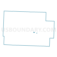
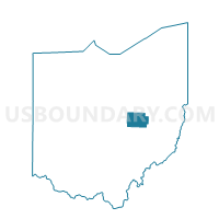
PRECINCT COSHOCTON 4-B, Coshocton County, Ohio
About
Outline

Summary
| Unique Area Identifier | 643795 |
| Name | PRECINCT COSHOCTON 4-B |
| County | Coshocton County |
| State | Ohio |
| Area (square miles) | 0.16 |
| Land Area (square miles) | 0.16 |
| Water Area (square miles) | 0.00 |
| % of Land Area | 100.00 |
| % of Water Area | 0.00 |
| Latitude of the Internal Point | 40.27129300 |
| Longtitude of the Internal Point | -81.84108050 |
Maps

Graphs
Select a template below for downloading or customizing gragh for PRECINCT COSHOCTON 4-B, Coshocton County, Ohio


Neighbors
Neighoring Voting District (by Name) Neighboring Voting District on the Map
- PRECINCT COSHOCTON 1-C, Coshocton County, OH
- PRECINCT COSHOCTON 3-B, Coshocton County, OH
- PRECINCT COSHOCTON 4-A, Coshocton County, OH
- PRECINCT COSHOCTON 4-C, Coshocton County, OH
- PRECINCT COSHOCTON 4-D, Coshocton County, OH
- PRECINCT LAFAYETTE WEST, Coshocton County, OH
Top 10 Neighboring County Subdivision (by Population) Neighboring County Subdivision on the Map
- Coshocton city, Coshocton County, OH (11,216)
- Lafayette township, Coshocton County, OH (4,081)
- Tuscarawas township, Coshocton County, OH (1,864)